Southwest Bowhunters
  • Home
  • Our Club
  • OUR SHOOTS
  • OUR SPONSORS
  • Videos
  • Membership & Shoot Prices
  • Upcoming Archery Events
  • JOAD
  • Youth & Adult Programs
  • Shoot Results
  • Photo Gallery
  • The Range
  • News, Forms & Gen. Info
  • Historical Photos
  • More
    • Home
    • Our Club
    • OUR SHOOTS
    • OUR SPONSORS
    • Videos
    • Membership & Shoot Prices
    • Upcoming Archery Events
    • JOAD
    • Youth & Adult Programs
    • Shoot Results
    • Photo Gallery
    • The Range
    • News, Forms & Gen. Info
    • Historical Photos
  • Home
  • Our Club
  • OUR SHOOTS
  • OUR SPONSORS
  • Videos
  • Membership & Shoot Prices
  • Upcoming Archery Events
  • JOAD
  • Youth & Adult Programs
  • Shoot Results
  • Photo Gallery
  • The Range
  • News, Forms & Gen. Info
  • Historical Photos

Our Range

Click to view larger photo.

The Site

Our archery site is located on land owned by a combination of Yuma County, the Welton Mohawk Irrigation & Drainage District, and the US Bureau of Reclamation. On this site, we have a lighted practice range and three trail ranges: The Canyon Trail, the West River Trail and the East River Trail.

Aerial view showing log trail and short trail 2 in a forested area.

The West River Trail


An aerial view of the West River Trail (right).

Aerial view of a forest trail from start to end point.

The East River Trail

Aerial of the East River Trail (left)

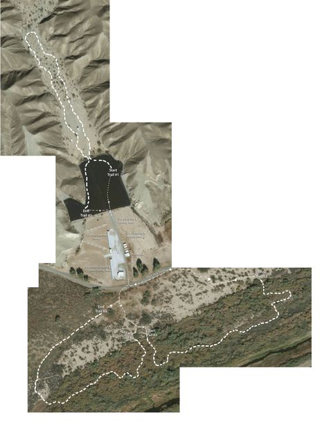
Aerial View of Entire Site

Above is an aerial view of the entire SWBH site with each of the three trails (top to bottom): Canyon Trail, Parking and Practice Range, West Trail (bottom left) and East Trail (bottom right).


Copyright © 2025 Southwest Bowhunters - All Rights Reserved.

Powered by